ODF crews making progress on multiple incidents, including Neil Creek Road Fire south of Ashland
By Steve Mitchell, Ashland.news
Crews capitalized on cool overnight temperatures Wednesday night to keep more than 70 fires burning in Jackson and Josephine counties from growing after they were sparked by lightning during a Monday evening thunderstorm.
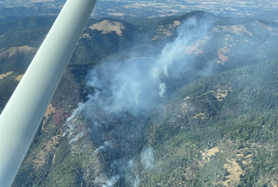
The Neil Creek Road Fire, the largest of the blazes, continues to burn on 250 acres south of Ashland and west of Interstate 5, according to fire officials. The blaze forced the closure of one lane on both the southbound and northbound sides of the freeway, according to the Oregon Department of Transportation.
According to Oregon Department of Forestry officials, firefighters built lines around the perimeter of the fire on Wednesday. A bulk of the effort went toward containing the fire along the freeway, on the fire’s southern edge.
Officials noted that firefighters started mop-up operations on the northern front of the blaze.
Meantime, a Level 2 “Be Set” evacuation notice remains in place for zones that surround the fire, which include JAC-536, JAC-542, JAC-543, JAC-546, JAC-558 and JAC-559.
A Level 2 “Get Set” evacuation notice means “Oregonians should be ready to leave at a moment’s notice, as this level indicates there is significant danger to the area,” according to Jackson County Emergency Management’s website. “The public should be prepared to voluntarily relocate to a shelter or with family/friends outside of the affected area. They may have time to gather necessary items, but doing so is at their own risk.”
ODF officials did not immediately respond to a request for comment.
The Deming Gulch Fire, northeast of Buncom in the Applegate, grew to roughly 250 acres by Thursday morning, according to an ODF report. Officials said crews built a line along the western side of the fire, but steep terrain and limited access have created challenges for crews on the ground.
Other notable fires in the area include:
The Heppsie Mountain Fire.
Located south of Highway 140, the blaze is about 40 acres in size, according to ODF officials.
Overnight crews caught two spot fires, each about 1.5 acres in size. Both of those fires are 100% lined, meaning a protective line is in place that leaves little chance for the fires to move beyond it. ODF reported the two spot fires were the only setbacks overnight.
According to officials, The Jackson County Sheriff’s Office and Emergency Management have issued a Level 1 – BE READY for a possible evacuation from the following areas: JAC-325-B Heppsie Mountain Road south of Highway 140 and the zone immediately to the south, JAC-326. More information on current evacuations can be found here: https://protect.genasys.com/.
The Poole Hill Fire
South of the Heppsie Mountain Fire, crews have built a protective line around 100% of the blaze, officials said. The fire is burning on more than 11 acres, according to ODF. Mop-up operations will continue today. Evacuation notifications for the Heppsie Mountain Fire apply to this incident as well, according to officials.
The Jim Me Peak Fire
Located in a remote area south of Applegate, the fire remains at about 70 acres, ODF reported.
“The fire remained very active overnight,” an ODF news release reads. “Resources will continue to be engaged in an aggressive attack as hot, windy conditions persist.”
The Palmer Peak Fire
Located to the southeast of the Jim Me Peak Fire, the blaze is about 90 acres. Crews have built a line around 90% of the fire, according to ODF.
Key resources:
OFFICIAL INFORMATION:
Jackson County Emergency Management: Facebook page with updates
ODF Southwest Oregon District: Facebook page with updates
Genasys Protect: Updated evacuation maps
Tripcheck.com: Information about road closures
Email Ashland.news associate editor Steve Mitchell at stevem@ashland.news.